
Note the defensive position of the fort, which was located on a bluff above the lakeshore and protected by Garrison Creek ravine. Later fill has extended the shore and changed the surrounding topography.
The crater at the lakeshore caused by the explosion of the powder magazine in 1813 is marked by 'D'. ”
- Isobel Ganton & Joan Winearls, MAPPING TORONTO'S FIRST CENTURY 1787-1884
With respect to the crater -- see the south side of the rampart. Read a detailed history of the crater here.
Click the image to view a full-size version.

Plan of the Fort at York Upper Canada shewing its state in March 1816. Drafted by: Royl. Engineers Drwg. Room, Quebec, 16th Feby. 1816, J[ean]. B[aptiste]. Duberger, Junr. Quebec, 24th June 1816, G[ustavus]. Nicolls, Lt. Col. Rl. Engineers.
Image courtesy Library and Archives Canada: NMC 22819. Winearls, MUC no. 2035
[The University of Toronto Map and Data Library has a black and white scan of this map (NMC23139), while the Toronto Public Library features a redrawn version (T1816-2/4Mlrg).]
The name of the surveyor/draughtsman, J.B. Duberger, and the date and place of the drawing can just barely be discerned, bottom right.
Nicolls and Duberger also created this accompanying, same-dated Plan of the harbour, fort and town of York, the capital of Upper Canada, March 16th 1816:
Click the image to view a full-size version.
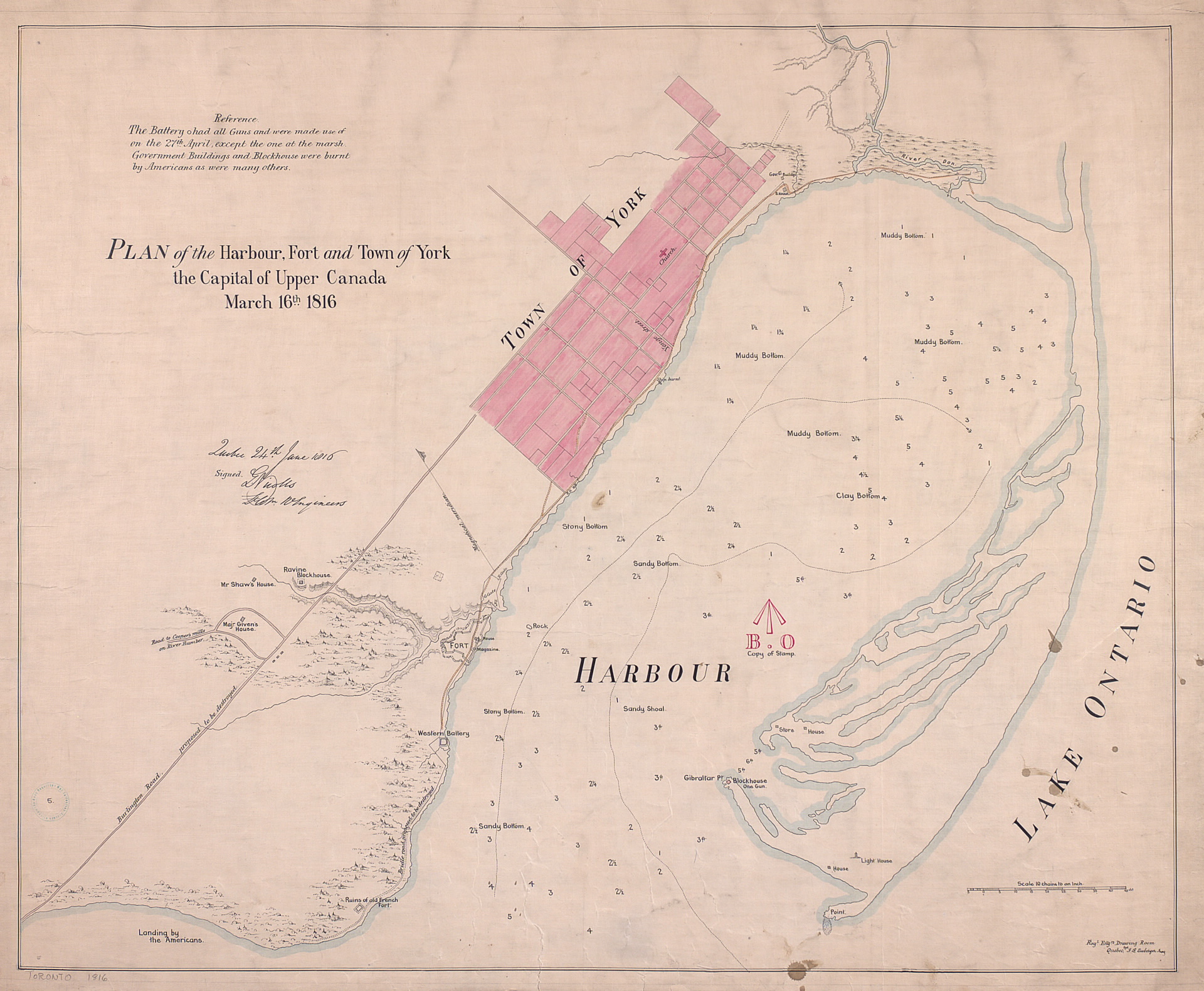
Image courtesy Toronto Public Library: T1816/4Mlrg [See also: LAC NMC 17441]
Winearls, MUC no. 2037
‘Signed Quebec 24th June 1816, G. Nicolls Lt. Coln. Engineers and Quebec. J. B. Duberger Jun'r. Shows buildings, harbour depths and descriptions of harbour bottom. Includes reference that The Battery had all guns and were made use of on the 27th of April, except the one at the marsh. Government buildings and blockhouse were burnt by Americans as were many others.’
Scale: 10 chains to an inch.
Gustavus Nicolls’ distinctive signature also appears on the 1833 Bonnycastle No.1 Plan of the Town and Harbour of York Upper Canada.
A few years later, Elias W. Durnford produced the following plan of the fort. It indicates the construction materials used for specific buildings.
Click the image to view a full-size version.

Plan of the fort at York, no. 24. E.W. Durnford, Sept 24, 1823.
Image courtesy Toronto Public Library: T1823/4Msm.
Durnford’s Fort plan, much like Nicolls’, was accompanied by a larger scale plan showing the relationship of the Fort to the Town:
Click the image to view a full-size version.

Plan of York, no. 24, See General Plan of the Canadies (y) E.W. Durnford, Sept 24, 1823
Image courtesy Toronto Public Library: T1823-2/4Msm
Unfortunately the key does not seem to be available...
See also
A wide swathe of maps relating to Fort York and the surrounding Military Reserve may be found at the Fort York and Garrison Common Maps project.
Please ‘Like’ and Share these maps with other Toronto history enthusiasts! (+1s are also welcome!)