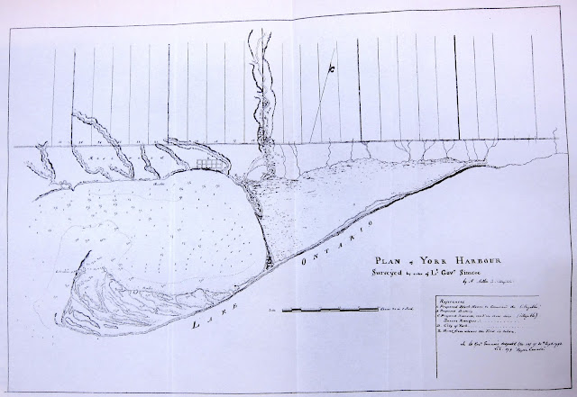
This map shows the earliest known plan of the Town of York. The 10-block "Old" town was laid out in 1793 on a site selected by Simcoe in the eastern part of the lands reserved for government and military use. Part of the first concession of York Township north of the township baseline (Queen Street) is also shown in its original form, before creation of the park lots.
Aitken surveyed the harbour and peninsula, and this map contains the first accurate depiction of the peninsula, the marsh, and the rivers and streams along the shoreline.’
- Isobel Ganton & Joan Winearls, MAPPING TORONTO'S FIRST CENTURY 1787-1884
The soundings for this map were taken by Joseph Bouchette.
Click the image to view a full-size version.
Plan of York Harbour Surveyed by order of Lt Govr Simcoe [Sgd] by A. Aitken. D [Syr?] 179[3]
Image courtesy The National Archives of the UK: CO 700 Canada no.60.
Winearls, MUC no. 2015
Digital Repatriation
The Aitken map was sent by John Graves Simcoe along with a letter he dispatched to Henry Dundas, Secretary of State for War (and the Colonies) in 1793. We—Canada—never got the map back; the original is held by the UK National Archives in their holdings of British military correspondence. As a result few Canadians have ever seen this version in its entirety, in colour; locally, only transcript copies have been available—until now.
Thanks to the generous support of Angie and Jeff Hocking (and their friends), I was able to obtain the above scan, and 'repatriate' this significant piece of Toronto’s history. I am very pleased to present it to you for general use and inspection.
Thanks Angie & Jeff for the help!
Here’s an transcripted excerpt from Simcoe’s letter (map reference highlighted):
Image courtesy TPL: Correspondence of Lieut. Governor John Graves Simcoe (Vol. 2, p58)
Other copies [the 'local' versions]:
The version below is a copy that was specially prepared for John Ross Robertson’s Landmarks of Toronto. It’s useful for sussing out the details of the map which may be faded on the original.
Click the image to view a full-size version.
Courtesy of Toronto Public Library: T1793/4Mlrg. Coloured manuscript; 1 inch to 20 chains.
Another version, a transcript copy:
A photo of the plan as it appears in the Correspondence of Lieut. Governor John Graves Simcoe (Vol. 2, p57):
See also University of Toronto photostat & this other copied Plan of York Harbour by Aitken (note D and E no longer in References).
Bonus — Simcoe’s ‘Military Street’
Just a few days after the above-mentioned correspondence, Simcoe set out to explore the country north of Lake Ontario. His aim was to establish communication between York and the British fur-trading post at Michilimackinac.
 |
| Queen's Rangers under Lieut. Governor Simcoe cutting out Yonge Street, 1795 by C.W. Jefferys (LAC) |
“I have ascertained by a Route hitherto unknown but to some Indian Hunters, that there is an easy Portage between York and the Waters which fall into Lake Huron of not more than thirty miles [about fifty kilometres] in extent, and through a Country perfectly suited for agricultural Purposes [...] I have directed the Surveyor [Augustus Jones] early in the next Spring to ascertain the precise distance of the several Routes . . . and hope to compleat the Military Street or Road the ensuing Autumn.”Correspondence of Lieut. Governor John Graves Simcoe (Vol. 2, p90)
Also of note: the 'Huts of the Queens Ranger' (sic), where Fort York would be established.
Road & Communication From York to Matchedash on Gloucester Bay
“Copied from a Plan of Scale four Miles to one Inch Surveyor Genls office Newark 22nd August 1794 (signed) W. Chewett
Image courtesy Toronto Public Library: 912.7134 O562. Winearls, MUC no. 318(2)
Sometime around 1797, David William Smith (another notable figure in early York history) drew the following plan of Yonge St. stretching from Lake Ontario up to Lake Simcoe:
[Yonge Street L. Ontario shewing the communications from York to Lake Simcoe with a project for settling the French Royalists] [Sgd] D. W. Smith, Act. Sur. Gen. Approved [Sgd] Peter Russell. Copy W.C.
Image courtesy Archives of Ontario: A-15. AO 1406. Winearls, MUC no. 327
The 'Acting' Surveyor General title allows us to approximately date the map, as Smith was confirmed Surveyor General January 1, 1798.
Note: Winearls contradicts this timeframe in MUC, suggesting “this appears to be a plan for allotting the twps of Uxbridge, Gwillimbury, and part of Whitchurch, and land north of Whitby for the Count do Puisaye’s settlement and was probably made about Dec 1798 (Russell, Correspondence 2:321); (OHIM 4.14)”


